本研究课题适合遥感、规划、地理信息系统等学科领域的学生与从业者
来源:原创 作者:学姐
编辑:学姐
CV方向遥感课题研究什么?
大规模城市土地覆被分类是遥感领域的经典课题,它引导着城市基础设施规划、产业布局、资源管理等,是政策制定者的重点关注内容之一。
同时,精细化的城市模型为智慧城市、智慧交通、城市气候环境的改善奠定了基础。
近年来,随着深度学习技术的发展,各头部科技公司与互联网企业也越来越重视城市模型的建设与投入,将新技术与算法引入到这一经典研究课题中。
例如,华为、商汤等企业近年来多次举办遥感图像分类与分割的挑战赛;阿里巴巴启动了城市大脑项目;腾讯成立了智慧城市事业部等等……
然而,对于学术界而言,高清的商业遥感卫星图像昂贵且难以获得,如何通过开源的中低分辨率卫星图像制作高精度的城市分类地图成为了挑战。
本课题将聚焦经典,完成基于开源遥感数据的大规模城市土地覆被分类实践,着重介绍世界城市数据库组织(World Urban Database and Access Portal Tools, WUDAPT)的方法和成果,并完成深度卷积神经网络的设计和在城市土地覆盖分类中的应用。
【课题】基于开源遥感数据的大规模城市土地覆被分类——WUDAPT方法与深度学习方法的比较
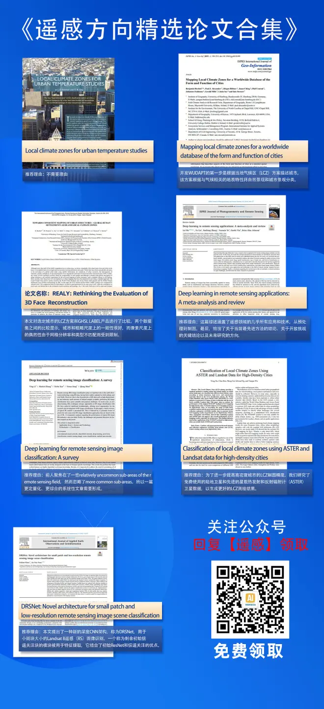
该方向必读论文如下
[1] Stewart, I.D. and T.R. Oke, Local climate zones for urban temperature studies. Bulletin of the American Meteorological Society, 2012. 93(12): p. 1879-1900.
[2] Bechtel, B., et al., Mapping local climate zones for a worldwide database of the form and function of cities. ISPRS International Journal of Geo-Information, 2015. 4(1): p. 199-219.
[3] Bechtel, B., et al., Towards consistent mapping of urban structure-global human settlement layer and local climate zones. ISPRS-International Archives of the Photogrammetry, Remote Sensing and Spatial Information Sciences, 2016. 41: p. 1371-1378.
[4] Ma, L., Liu, Y., Zhang, X., Ye, Y., Yin, G., & Johnson, B. A. (2019). Deep learning in remote sensing applications: A meta-analysis and review. ISPRS journal of photogrammetry and remote sensing, 152, 166-177.
[5] Li, Y., Zhang, H., Xue, X., Jiang, Y., & Shen, Q. (2018). Deep learning for remote sensing image classification: A survey. Wiley Interdisciplinary Reviews: Data Mining and Knowledge Discovery, 8(6), e1264.
[6] Xu, Y., Ren, C., Cai, M., Edward, N. Y. Y., & Wu, T. (2017). Classification of local climate zones using ASTER and Landsat data for high-density cities. IEEE Journal of Selected Topics in Applied Earth Observations and Remote Sensing, 10(7), 3397-3405.
[7] Chen, F., & Tsou, J. Y. (2021). DRSNet: Novel architecture for small patch and low-resolution remote sensing image scene classification. International Journal of Applied Earth Observation and Geoinformation, 104, 102577.
论文领取方法
本研究课题适合遥感、规划、地理信息系统等学科领域的学生与从业者,以及所有有志于贡献开源数据社区WUDAPT的人员。
有遥感方向发论文需求的同学可以联系小享咨询1V6论文班服务!